Previous Drilling Confirms High Grade Lithium Mineralisation At Piedmont Lithium Project

ANNOUNCEMENT TO THE AUSTRALIAN SECURITIES EXCHANGE | October 18, 2016 | ASX:WCP
 161018_previous_drilling_confirms_high_grade_lithium_mineralisation-1.pdf
- Assay results from 19 previously drilled core holes confirm high grade lithium in multiple spodumene-bearing pegmatites at the Company’s 100% owned Piedmont Lithium Project
- The Project is located within the historic Carolina Lithium Belt and along trend from the Hallman Beam and Kings Mountain mines which provided a significant portion of the western world’s lithium between 1950 and 1990 making it a prime location to recommence activities
- Thick zones of high grade mineralisation have been recorded at shallow depths, with selected intercepts including:
- 5.5m @ 1.48% Li2O from 44m and 5.4m @ 1.48% Li2O from 59m (hole 10-BD-18)
- 6.9m @ 1.42% Li2O from 63m and 1.9m @ 2.83% Li2O from 72m (hole 10-BD-17)
- 7.9m @ 1.33% Li2O from 28m and 1.5m @ 2.17% Li2O from 85m (hole 09-BD-05)
- 6.0m @ 1.31% Li2O from 81m and 8.0m @ 1.34% Li2O from 197m (hole 10-BD-14)
- 13.0m @ 1.24% Li2O from 43m (hole 09-BD-06)
- 12.0m @ 1.18% Li2O from 29 m (hole 09-BD-03)
- 4.7m @ 1.54% Li2O from 28m (hole 09-BD-10)
- Importantly, the frequency of pegmatites gives the Company confidence in defining a potentially mineable deposit with cumulative thicknesses (excluding waste) including:
- 31 metres of cumulative thickness across 8 pegmatites (hole 10-BD-17, Figure 1)
- 21 metres of cumulative thickness across 2 pegmatites (hole 09-BD-03)
- 19 metres of cumulative thickness across 3 pegmatites (hole 10-BD-14)
- 17 metres of cumulative thickness across 4 pegmatites (hole 09-BD-05)
- The Company now has a solid basis from which to develop an exploration campaign with the goal of defining a strategic North American lithium deposit and will pursue the
commencement of a follow up drilling campaign in the next few weeks WCP will also undertake a land leasing program expanding out from its strategic
Piedmont Lithium Project area and is currently in negotiations with multiple landowners - WCP aims to leverage its position as a first mover in restarting exploration in this historic lithium producing region with the aim of developing a strategic, U.S. domestic source of lithium to supply the growing Electric Vehicle and Battery Storage markets in the U.S.
- WCP’s point-of-difference within the lithium industry is its unique proximity to existing infrastructure and downstream lithium processing facilities, providing the potential for lower operating and capital costs
WCP Resources Limited (“WCP” or “Company”) (ASX: WCP) is pleased to announce that recently acquired historical exploration data confirms significant potential for the Piedmont Lithium Project (“Project”) to host a strategic, US domestic lithium source for the growing demand for lithium batteries used in Electric Vehicle and Battery Storage markets.
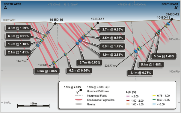
Figure 1: Project Cross Section showing high frequency of Lithium Bearing Pegmatites
The Project is located in Gaston County, North Carolina, USA, approximately 40 kilometres west of Charlotte, and consists of options over an initial core landholding of 415 contiguous acres. Geologically, the Project is located within the historic Carolina Lithium Belt, also referred to as the Carolina Tin-Spodumene Belt (“TSB”), a narrow northeast-southwest trending zone that extends for approximately 60 kilometres through Lincoln, Gaston, and Cleveland counties in North Carolina before terminating in Cherokee County in South Carolina.
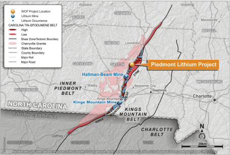
Figure 2: Project Location within Carolina Tin-Spodumene Belt
The TSB saw lithium exploration as early as the 1950’s which resulted in significant lithium discoveries (Hallman Beam Mine and the Kings Mountain Mine) that produced until the late 1990’s.
The Project is focused over an area that has been explored for lithium dating back to the 1950’s where it was originally explored by Lithium Corporation of America which was subsequently acquired by FMC Corporation. Most recently, North Arrow Minerals Inc. (“North Arrow”) explored the Project in 2009 and 2010, prior to North Arrow changing its focus to gold and base metal opportunities due to the significant fall in lithium price in 2010. The Company has now obtained North Arrow’s exploration data which is reported in this announcement.
North Arrow conducted surface sampling, field mapping, a ground magnetic survey and two
diamond drilling programs for a total of 19 holes. Surface samples returned 16 of 18 samples
(grab outcrop or float) with greater than 1% Li2O and field mapping outlined over 37
spodumene-bearing pegmatite dikes.
Previous Drilling Results
The 2009 and 2010 diamond drilling programs undertaken by North Arrow consisted of 19 holes totalling 2,544 metres. North Arrow collected a total of 543 assay samples from 17 of the 19 holes, no assay samples were collected from two holes. The drill holes were designed to test spodumene-bearing pegmatites identified from surface geological mapping. Seventeen of the 19 holes intersected significant spodumene-bearing pegmatite, with the individual intercepts ranging in thickness from 1 to 13 metres (down-hole thickness). The pegmatite intercepts typically returned weighted assay results from 0.8% to 1.5% Li2O.
Commonly multiple spodumene-bearing pegmatites are intersected within the drill holes. As an example, 8 individual mineralised pegmatites were intersected in Hole 10-BD-17. The interpreted cross-section for holes 10-BD-16, 17 and 18 (Figure 1) shows the stacked nature and steep to moderate easterly dip of the pegmatites.
The pegmatites predominantly trend northeast-southwest, and are hosted in an amphibolebiotite gneiss that rarely outcrops due to a deep weathering profile. Generally, the pegmatites intersected in drilling correlate well with the surface exposures observed in the geological mapping.

Figure 3: Photograph of spodumene pegmatite core with two types of mineralization, coarse grained (left) and fine grained sucrosic (right)
Spodumene mineralisation observed in the drill core ranges from crystals 1 millimetre to 10 centimetres in length (Figure 3). Occasionally crystals up to 30 centimetres in length have been observed in surface outcrop.
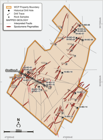
Figure 4: Project Area showing Mapped Spodumene Pegmatites, Drill Holes and Rock Sample Locations
All significant intersections returned from the 2009/2010 drill holes, along with the details of the collar positions, drilling orientations and depths, are summarised in Appendix 1.
Previous Rock Chip Results
North Arrow’s initial work in 2009 consisted of surface sampling. A total of 18 samples were collected within the Project area, consisting of selective grabs from pegmatite outcrop and float boulders. The objective of the sampling program was to confirm spodumene mineralisation within the area (not to define grade over thickness).
The assay results yielded 16 samples with >1% Li2O, confirming spodumene-bearing pegmatites across a broad area of the Project, including areas outside of the initially drilled targets. The locations of the samples are shown in Figure 4 and the sample descriptions and assay results are summarised in Appendix 2.
TSB Geology
Geologically, the Project lies in the Inner Piedmont belt adjacent to the Kings Mountain shear zone, which separates the Inner Piedmont belt from the Kings Mountain belt to the east.
The Inner Piedmont belt is typically characterized by Cambrian or Neoproterozoic gneisses, amphibolites, and schists of varying metamorphic grade (Gair, 1989). These rocks all lack primary structures and their relationships between one another is undetermined (Gair, 1989). Several major intrusions occur in the Inner Piedmont, including the nearby Mississippianaged Cherryville granite (Kish, 1983). Concurrent dike events extend from the granite, mainly to the east, with a strike that is sub-parallel to the northeast trending Kings Mountain shear zone. As the dikes progressed further from their sources, they became increasingly enriched in incompatible elements including lithium. The enriched pegmatitic dikes are located within a 3.5 kilometres wide zone extending from the town of Kings Mountain through Lincolnton, this zone is known as the Carolina Tin-Spodumene Belt (Figure 2). The Project lies within the TSB.
TSB Infrastructure
The Project area is intersected by state maintained paved secondary roads. Interstate I-85, a major east coast transportation corridor, lies 13 kilometres to the south and provides access to the city of Charlotte and the Charlotte Douglas International airport via a 30 minute drive. In addition to excellent access, electrical power infrastructure is in place providing power to nearby residents and property owners. A railway is accessible less than 5 kilometres to the north and 13 kilometres to the south of the Project.
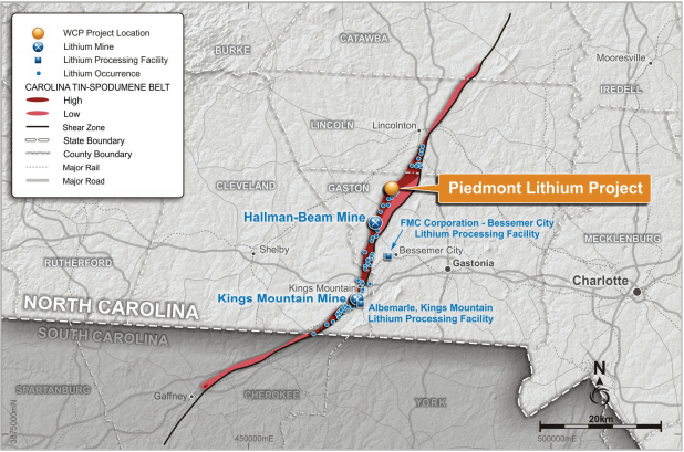
Figure 5: Project Location and Regional Infrastructure
Albemarle and FMC continue to operate two of the most important lithium processing facilities which are situated on these sites as a result of the rich deposits of lithium contained in the TSB. These facilities are now at the forefront of lithium research and development with FMC maintaining the Center for Lithium Energy Advanced Research (“CLEAR”) lab in Bessemer City, proximal to the Project. FMC’s Bessemer City lithium processing facility is approximately 14 kilometres from the Project whilst Albemarle’s Kings Mountain lithium processing facility is approximately 17 kilometres from the Project (Figure 6).
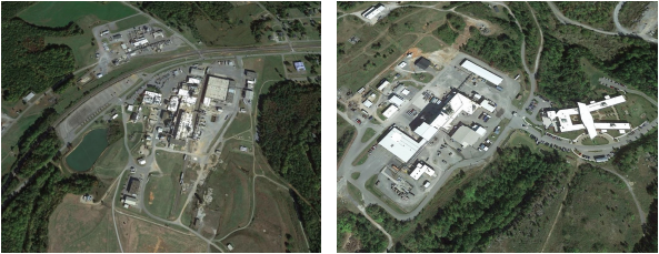
Figure 6: FMC and Albemarle Lithium Processing Facilities
The region is one of the premier localities in the world to be exploring for lithium pegmatites given its favourable geology and ideal location with easy access to infrastructure, power, R&D centres for lithium and battery storage, major high tech population centres and downstream lithium processing facilities. The Company is in a unique position to leverage its position as a first mover in restarting exploration in this historic lithium producing region with the aim of developing a strategic, U.S. domestic source of lithium to supply the increasing electric vehicle and battery storage markets.
Forward Looking Statements
This announcement may include forward-looking statements. These forward-looking statements are based on WCP’s expectations and beliefs concerning future events. Forward looking statements are necessarily subject to risks, uncertainties and other factors, many of which are outside the control of WCP, which could cause actual results to differ materially from such statements. WCP makes no undertaking to subsequently update or revise the forward-looking statements made in this announcement, to reflect the circumstances or events after the date of that announcement.
Competent Persons Statement
The information in this announcement that relates to Exploration Results is based on, and fairly represents, information compiled or reviewed by Mr Lamont Leatherman, a Competent Person who is a Registered Member of the ‘Society for Mining, Metallurgy and Exploration’, a ‘Recognised Professional Organisation’ (RPO). Mr Leatherman is a consultant to the Company. Mr Leatherman has sufficient experience that is relevant to the style of mineralization and type of deposit under consideration and to the activity being undertaken to qualify as a Competent Person as defined in the 2012 Edition of the ‘Australasian Code for Reporting of Exploration Results, Mineral Resources and Ore Reserves’. Mr Leatherman consents to the inclusion in the report of the matters based on his information in the form and context in which it appears.
For further information, contact:
President & CEO (elect)
T: +1 973 809 0505
Executive Director
T: +1 347 899 1522
